New FEMA flood maps would put 134 Lafayette County parcels in the high-risk flood area for the first time. Owners can check their land and comment until Jan. 12.
New federal flood maps for Lafayette County would change the flood risk on 607 parcels of land. For 134 of them, it would be the first time they sit in the high-risk flood area.
Lafayette County announced the preliminary Flood Insurance Rate Maps on Thursday, Nov. 12. FEMA drew them after a new engineering study of the Yocona and Little Tallahatchie watersheds. The county said the maps are expected to take effect in late 2027 and that FEMA has mailed notices to the owners of affected property.
The county’s current flood maps date from 2010.
Overview
- 607 parcels in Lafayette County have a changed flood elevation, a changed high-risk boundary, or both, on the county’s list.
- 134 would move into the high-risk area. 77 would come out of it.
- Nothing changes yet. The maps are a proposal and are expected to take effect in late 2027.
- Look up a property on the county’s flood map lookup by parcel number, address, road or creek.
- Comments and appeals: FEMA’s notice asks for comments by Jan. 12, 2027. The county says a formal 90-day appeal period is expected this fall.
What changes, parcel by parcel
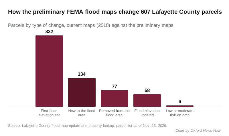
The county’s lookup sorts the 607 parcels by the kind of change:
| Change on the preliminary maps | Parcels |
|---|---|
| Already high risk, flood elevation set for the first time | 332 |
| New to the high-risk flood area | 134 |
| Removed from the high-risk flood area | 77 |
| Existing flood elevation revised | 58 |
| Low or moderate risk on both maps | 6 |
The biggest group is land that was already high risk but never engineered. On the 2010 maps it is Zone A, with no calculated flood height. The study now sets a base flood elevation, the height water is expected to reach in a flood with a 1% chance of happening in any year.
The county called that change “usually good news.” With a known flood elevation, an elevation certificate can show a building sits above it, which can lower a flood insurance premium, the county said.
The lookup also flags 109 parcels as newly in the regulatory floodway. That is the channel and the land beside it that must stay clear to carry flood water, and building there is tightly restricted, the county said.
Which creeks, and how many buildings
The changes follow the creeks the study measured. Counting the parcels the county lists against a single creek, the largest groups are:
- West Goose Valley Creek, 150 parcels
- Yellow Leaf Creek, 105
- Burney Branch, 102
- Taylor Creek, 65
- a tributary of Berry Branch, 60
Most of the land has nothing built on it inside the shaded area. The county said a building is touched or covered by the high-risk shading on 53 parcels. On 188 a building is mapped but sits clear of it. The other 366 have no building inside the parcel outline.
By our count of the county’s list, 26 of the 53 parcels with a building in the shading are new to the high-risk area. The county said its building outlines come from 2022 and miss some newer homes and outbuildings.
All 607 parcels carry county addresses: 549 in the 38655 ZIP code and 58 in Taylor’s 38673. None sits inside Oxford’s city limits, by our check of each parcel’s mapped location against the Census Bureau’s boundary for the city. FEMA’s Oct. 14 notice in the Federal Register lists the city of Oxford, unincorporated Lafayette County and the village of Taylor as the communities in the study. Taylor is about six miles south of Oxford.
When it takes effect
The county laid out the steps:
- Appeal period. FEMA opens a 90-day window with notices in the Federal Register and twice in a local newspaper. The county expects it this fall.
- Final determination. Once appeals are settled, FEMA sends the county a Letter of Final Determination.
- Six months to adopt. The county then has six months to adopt the maps and an updated floodplain ordinance.
- New maps in force, expected in late 2027.
FEMA’s Federal Register notice gives Jan. 12, 2027, as its comment deadline, under docket FEMA-B-2635.
What it means for you
If your land is new to the high-risk area and you have a mortgage, your lender will have to require flood insurance on the building once the maps take effect, the county said. The lender enforces that, not the county. Without a mortgage, insurance is not required.
The county said a standard homeowner’s policy does not cover flood damage. A new flood policy normally takes 30 days to start. The county advised owners moving into the high-risk area to talk to an insurance agent before the maps take effect, not after. It said the flood maps have no direct effect on property tax assessments.
If you think the map is wrong for your property, you have three routes, the county said:
- Appeal during the 90-day window, backed by a survey or engineering analysis from a licensed professional. Appeals must be supported by data, “not by opinion or by the absence of past flooding,” the county said.
- Letter of Map Amendment, if a surveyor’s elevation certificate shows the building or lot is on natural ground above the flood elevation. FEMA charges no fee; you pay for the survey. It can be requested at any time.
- Letter of Map Revision Based on Fill, if the lot was raised with engineered fill. FEMA charges a review fee.
Paper copies of the preliminary maps are held at the community map repositories FEMA listed:
- City of Oxford: City Hall, 107 Courthouse Square
- Unincorporated Lafayette County: Chancery Courthouse, 300 N. Lamar Blvd.
- Village of Taylor: Town Hall, 12 Main St., Taylor
For questions about a property, the county said to call Elliott and Britt Engineering at 662-234-1763. The current maps can be compared on FEMA’s Map Service Center.
Have your say